
Cyclone likely in next 12 hours, deep depression created
A low-pressure area developing over the southwest Bay of Bengal and adjoining Sri Lanka coast has intensified into a cyclonic storm . There is no threat to Odisha as of now.
It will become stronger within 12 hours.
By Thursday morning, a developed weather system over the southwest Bay of Bengal and adjacent Sri Lanka coast has intensified into a low-pressure area and is likely to strengthen further during the next 12 hours.
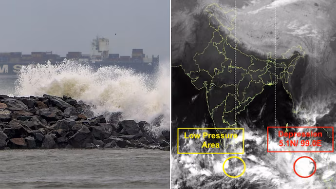
A cyclonic circulation system is currently active in the Bay of Bengal . Meanwhile, a deep depression formed in the South Andaman Sea has moved west-northwestwards and is expected to intensify into a cyclonic circulation. According to the Indian Meteorological Department, it is likely to intensify into a cyclonic circulation ‘Senya’ and cross the Indonesian coast.
However, while the impact of this system is not felt in Odisha, the low pressure formed in the Sri Lankan coastal sea may develop into a cyclone by the 28th or 29th. Various models have estimated that the impact of the possible cyclone will be in Tamil Nadu and Andhra Pradesh. However, it is predicted that some districts of South Odisha of the state may experience a cyclone between the 30th and December 2nd due to the impact of the possible cyclone formed in the Sri Lankan coast.
According to the India Meteorological Department (IMD), the system is likely to intensify into a deep depression as it moves northwestwards over the sea. Its formation has raised fresh concerns about the possible formation of a cyclonic storm in the Bay of Bengal, though the agency has not issued any forecast on its impact on Odisha.
The IMD said that the cyclone is currently centered over southwest Bay of Bengal and waters off Sri Lanka. It is likely to intensify further as it moves towards Tamil Nadu-Puducherry-South Andhra Pradesh coasts. At present, no assessment has been made about its impact on Odisha.
Parallel cyclone over the Malacca system
The Bay of Bengal is moving with another system which has recently strengthened into Cyclone Senyaar over the Malacca system.
Senya has formed from a deep depression. It is currently located east of the Indonesian coast. Its movement is centered over Southeast Asian waters. Weather models indicate that the cyclone will change direction over the surrounding seas without threatening the Indian mainland, including the Odisha coast.
It is located 700 km from the Nicobar Islands and 150 km from Indonesia. It is said that it may touch the land of Sennar on the Indonesian coast. On Thursday, the IMD predicted that it is likely to make landfall.Weather models indicate that Senya’s trajectory is far from the central Bay of Bengal trough.
Odisha forecast remains stable
With two systems active in the region, weather impacts are expected over Tamil Nadu, Puducherry and parts of South Andhra Pradesh. The Bay of Bengal system will increase in strength and move towards those coasts.
The situation in Odisha is expected to remain calm. The regional IMD centre in Bhubaneswar has predicted dry weather in all districts till December 2, with scattered cloud cover being the only possible development. No rain advisory has been issued for the state associated with either system.
ALSO READ : smriti mandhana marriage